On 23 and 24 July, just before the national heat record was set, the researchers sent up a special, biodegradable weather balloon every two hours. Under the balloon hung a cup containing equipment for measuring the temperature, humidity and position. The main aim was to establish the extent of the ‘heat island effect’, explains meteorologist Gert-Jan Steeneveld. That is the phenomenon whereby heat lingers longer in cities than outside them. The difference can be up to five degrees Celsius. But what this kind of heat island looks like in 3D – from the ground to the upper atmospheric layers – was not yet understood. And that was precisely the information needed to improve weather models, says Steeneveld.
At its thickest, the heat island reached a height of 120 metres. At that height, the temperature was the same as that above the countryside. The influx of hot air from the south in the upper atmospheric layers also helped maintain the heat island. Steeneveld: ‘So no mingling takes place. That causes the heat and all the air pollution to linger above the city.’
The heat island effect reached a height of 120 metres
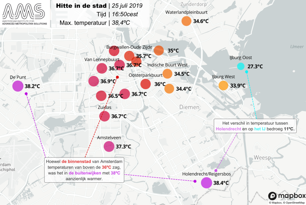
The measurements also show that heat levels in the city vary a lot. The city centre was the ‘coolest’, with temperatures around 36 degrees. In the outer suburbs they went higher than 38 degrees. The difference has to do with the height of buildings and the width of the streets. The narrower streets lined with tall buildings in the centre remain shady for longer. And nearby water (the IJ) provides cooling too.
The temperatures measured were better than expected. Steeneveld used the adjusted weather model and several climate scenarios to calculate what cities such as Amsterdam can expect in the future. Daytime temperatures of 43 degrees will not be exceptional on a hot day in Amsterdam.


 Meteorologist Gert-Jan Steeneveld sends up weather balloons on the Dam in Amsterdam, to great press interest. Photo: AMS Institute