Photo: Bram te Brake
One can measure how wet surroundings get, as precipitation can be measured in a myriad of ways. But it is much more difficult to image how moist the soil is – how much water it contains, explains hydrologist Bram te Brake. ‘One can’t just take a quick look in the soil.’ This Wednesday, he will defend his PhD thesis on the use of radar images to measure water storage by way of soil shrinkage.
Radar
The method that Te Brake used is called radar interferometry. Information on the vertical placement of the soil is extracted from the radar images provided by a passing satellite. This can be done with surprising accuracy. Depending on the wavelength used by the radar, it is possible to measure whether the soil rose or fell to within a few millimetres between two measurements.

The use of radar interferometry to map changes of the surface is nothing new, explains Te Brake. ‘It is used increasingly often to image the consequences of earthquakes, volcanic activity or the extraction of oil, gas or water. In Groningen, this method is used to measure the subsidence of the soil.’ But imaging clay shrinkage and finding a relation between that shrinkage and the moisture levels is new.
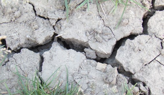
Clay-rich soil shrinks when it dries. It becomes visible when the soil starts to tear. However, this shrinkage occurs not only across the surface of the soil, but also along the vertical direction. And this subsidence – or expansion – can be deduced by comparing radar images that have been taken at time intervals. Te Brake did this for clay soils in the Purmer polder in North Holland, using a German satellite that took images at intervals of eleven days. The PhD candidate linked the radar signals to the shrinking behaviour of the soil.
It becomes impossible to measure starting June, as the signal is disrupted by vegetation.
Bram te Brake
However, it is not as simple as it seems. The radar images also have their limitations, as is apparent from Te Brake’s work. This is caused by the disruptive effect of the soil coverage. The radar does not differentiate between the soil and anything that grows on it. ‘When using the short wavelength that I used (3,1 centimetres), it becomes impossible to measure starting June, as the signal is disrupted by vegetation.’ According to Te Brake, measuring using a longer wavelength could solve this problem.
Shrinking behaviour
Moreover, the shrinking behaviour of clay-rich soil turned out to be more complicated than Te Brake had expected. In an ideal scenario, clay will shrink at identical ratios in all directions upon loss of moisture. However, lab tests with small chunks of clay showed that this relation is only partially linear. The shrinking behaviour of real soils out in the field is even more fickle. All this makes that a proper calculation of the changes in water storage is difficult.
The principle of the measurements works, as Te Brake proves in his PhD thesis. But because of all these inconveniences, practical usability for water management is still far off. ‘This is highly explorative research and the circumstances were far from ideal. The soil in the Purmer contains 25% of clay at most, which is not a lot. Heavier clay soils exist, whose shrinking behaviour is far more ideal for this method.’ Besides, per Te Brake, it has been proven that clay shrinkage has a clear effect on the radar signal, which means that this signal will require corrections when used in other applications.